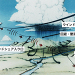
2020年1月22日の第1回および4月11日の第2回で紹介したが、LiDARは、Light Detection and Ranging (光検出と測距)もしくはLaser Imaging Detection and Ranging (レーザー画像検出と測距)の略で、光を用いたリモートセンシング技術の一つである。今回は、航空への応用、特に空港付近での風の計測のためのLiDARを中心に紹介する。ウインドシアと呼ばれる大気の現象を滑走路の近くに設置したLiDARあるいは航空機搭載のLiDARで検知することは、離発着時の墜落事故の防止策として重要である。(As explained in the reports dated January 22 and April 11, LiDAR, the acronym of Light Detection and Ranging or Laser Imaging Detection and Ranging, is one of remote-sensing technologies applying optics. In this report, the applications of LiDAR for aviation fields are introduced, especially, to measure the wind near airports. It is quite important to detect wind shear, dangerous atmospheric phenomenon, to avoid clash of aircrafts in their takeoffs and landings by the LiDAR equipment installed near runways as well as on aircrafts.)